My First Atlas of the 50 States
by Georgia Beth
This title was previously available on NetGalley and is now archived.
Send NetGalley books directly to your Kindle or Kindle app
1
To read on a Kindle or Kindle app, please add kindle@netgalley.com as an approved email address to receive files in your Amazon account. Click here for step-by-step instructions.
2
Also find your Kindle email address within your Amazon account, and enter it here.
Pub Date 17 Sep 2019 | Archive Date 1 Oct 2019
Quarto Publishing Group - QEB | words & pictures
Talking about this book? Use #MyFirstAtlasOfThe50states #NetGalley. More hashtag tips!
Description
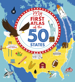
Go sight-seeing in California to find the famous Hollywood sign, journey through the mountains in Idaho to spot a black bear, and venture north in New York state to view the beautiful Niagara Falls. There's so much to see!
Every state has its own dedicated page containing feature boxes and "Fast Facts" panels, while a map of the full country shows how each state fits into the USA. This exciting first atlas engages young readers, encouraging them to learn about their own country—a must for any young citizen's book shelf.
Marketing Plan
Key Selling Points: Bold and colorful first atlas of the USA. Maps show state borders, cities, cultural features, animals, natural wonders and famous landmarks. Each map includes "sight-seeing" features and a Fast Facts panel.
Publicity: Pitch to homeschooling magazines Pitch to National Geographic for inclusion in online resources Pitch to outlets focused on social studies Pitch to National Council for Geographic Education (NCGE) for inclusion in newsletters and children’s activities (including K-12 resources list) Targeted outreach to kidlit bloggers and bookstagrammers focused on illustration
Trade & Consumer Promote during Geography Awareness Week (November 2019) in conjunction with the organization Start With a Book Tee up for Independence Day (July 2020) Create a “My First” books sell sheet Create an “Atlas” sell sheet Create an “Earth Science” sell sheet Add to “Geography” sell sheet
School & Library Submit for all eligible awards Promote at School & Library shows Display at shows and include in educator email Select mailing to education/librarian contacts Create a Teacher Guide
Available Editions
| EDITION | Other Format |
| ISBN | 9780711242890 |
| PRICE | $18.95 (USD) |
| PAGES | 64 |
Average rating from 20 members
Featured Reviews
 John L, Reviewer
This book serves its purpose well, giving us all a basic grounding in the 50 different US states. We get a map of the country, and then of the continent's biomes, before we spread out and absorb the states one by one. The maps are suitably colourful, showing the main cities, and the location of the more major sites – some of which (Mt Rushmore, the Gateway Arch etc) get a separate sentence or two as caption. The rest of the space is peppered with suitable fauna and other details geographers would likely note. A small data box on each page lets you learn just how many have the same state bird, which is something of no use whatsoever outside of the US, but I'll forgive this book for going down that route. It is, after all, very good. It might have given separate space to DC, I thought, and it doesn't say why Indiana, at most a third of the way from the eastern side, is called Midwestern, but that's again for the Americans to address. A strong four stars.
When I was about ten years old, my mom bought be an atlas of the U.S. that was published by Golden Books. I had been wanting the book for some time. I thought about how much I enjoyed that book when I received this one in exchange for an honest review from NetGalley and the publisher.
This book is an excellent and interesting introduction to the United States. Following a welcome page, there is a section on the biomes of North America and then the states...each one has beautifully, lively illustrated pages. Readers will learn "Fast Facts." These include the size and population of the state, along with when it joined the Union, the State nickname and the State bird. Each map has pictures imposed on it that show sites, crops, animals and more. There are also additional illustrations that highlight places to visit. For example, there is the Grand Ole Opry in Tennessee, the Crystal Bridges Museum in Arkansas, the mansions in Newport, Rhode Island and so much more.
Help a child you know to learn geography. This book can be read in the order given or randomly. It is a good resource and will be enjoyed by both adults and kids.
Colorful and enticing, My First Atlas of the 50 States offers a wonderful introduction to geography for the beginning reader. Presented geographically by region, each state is given a page with a brief description, often including the origin of the states name (many of which I didn’t know), what the state is known for, and other key facts. For example, the book notes that most of the country’s airline production is completed in Kansas!
Each page has a call out “Fast Facts” box with the state’s size, population, date it joined the country, nickname, and state bird—all facts handy to have in single location. The only photographs are notable tourist attractions, such as the gateway arch in Missouri or the San Antonio River Walk in Texas. The states themselves are vibrantly illustrated and include adorable icons of animals, flora, and landmarks. Capitals and major cities, but no roads or minor cities are indicated.
Of course, having to select such a small amount of information for each state would be challenging and requires making difficult decisions about what to include, but it seemed Beth avoided difficult topics. As a native Oklahoman, I was shocked that the Oklahoma City National Memorial wasn’t one of the points of interest. Slavery and racism were addressed, though described as “a difficult time.” I understand this allows guardians to decide how to discuss the issue with children, but it also seems to negate an important part of the South’s reality.
While I loved the illustrations of the maps and the icons they included, they could at times be confusing. New York has a marker for the National Baseball Hall of Fame and Museum but the city in which it is located isn’t marked, so the icon seems to be floating in the middle of the state. There is a hot dog icon, too, I suppose in honor of New York City’s street vendors, but it is placed “not to scale.” Maryland has an icon for jousting which is never explained. Still, I think children will enjoy looking at the icons and identifying them, especially those that represent animals—at least I did!
The book, though, does what it promises—provides a great first atlas for young readers to help them learn about the basic geography of the country and facts of the states.
My First Atlas of the 50 States is a vividly illustrated book for children with information on all fifty states. Each page has information and illustrations about the state, including fun facts, the capitol, little blurbs about things each state is known for and biggest tourist attractions.
I enjoyed this book. It is a great learning tool for kids and a really great visual for road trips!
Lisa R, Reviewer
Found this to be a really nice look at all 50 states - my five year old loved it. A great addition to any library!
 Reviewer 417139
Really enjoyed reading "My First Atlas of the 50 States." This is a perfect version for young children. The different imprint of the publisher released an advanced version few years ago but that version includes far too much information for young children to absorb. I am delighted to know the publisher introduces a starter book on the same subject for younger readers.
1- The organization of the content is easy to follow. Instead of listing the states in alphabetical order, the book starts from the west coast and slowly moves to the east. This arrangement is perfect for children (even for adults) to create a mental map of the U.S. states geographically as readers flip through the pages.
2- Contents include succinct information readers should know about each state. No overloading with graphics or text which is great for retaining readers' interests and concentration.
3- The book also includes a catchy U.S. map with very brief history about the country. A spread about the North America continent and the biomes map of the North America region is such a thoughtful touch.
This is a definite book to keep and to own.
My First Atlas of the 50 States by Georgia Beth is a cute little starter atlas for small kids. It has very basic facts and cute little illustrations but it is not a book I would recommend to anyone that wants more than a glance about each state. I do like how the bright colors and short sentences could help a small child just starting out reading stay focused.
Danielle L, Reviewer
Great great book about the United States! It has great facts about each state and beautiful illustrations. I wish I had a book like this when I was a kid. Thank you for the opportunity to read and review this book.
Reviewer 186721
Very colorful. You get a good idea of all the famous spots, animals and activities in each state. There are some basic facts like size , population and fun facts like pineapple maze.
This is a bold and fact-filled atlas of America's 50 states, from Alabama to Wyoming, which highlights each state’s most iconic features from animals to famous foods and landmarks.
Each state has its own double-page, complete with map, photos of the famous features and a facts box. My favourite had to be New York. I love New York and this spread is full of the reasons why. Top of the list being Central Parc!
What I love about this atlas which you can see on this spread (and is true for all 50 states) is that Georgia and Sara have created the perfect balance between facts, photos and illustrations, that makes it accessible to young readers.
This is a perfect gift and keepsake book for a travel-loving and curious young reader. I’ve learnt a lot from this book! There is so much children can point out and relate to on each page. Whether they love animals, food, nature or just generally want to learn more about what makes each state of America unique, this is a great addition to any illustrated non-fiction collection. It’s so much more than just an atlas!
I am very grateful to the publisher for providing me with an advanced digital copy via Net Galley in exchange for an honest review.
**Links to be updated**
Jill H, Reviewer
Thank you to NetGalley and Quarto Publishing Group – QEB for My First Atlas of the 50 States by Georgia Beth. This is an atlas full of fun facts about each state. Each state has a list of “Fast Facts” that include size, population, nickname, state bird (the western meadowlark and the northern cardinal each represent several states), and the date the state joined the union. Each state also has small icons decorating it that represent animals, landmarks, main attractions, etc. in each state. This book is informative and fun to read. I learned that Oregon has Moon Country lava fields were astronauts trained to walk on the moon. Idaho means “Gem of the Mountains.” Kansas has a Wizard of Oz Museum. And Alabama’s Dismals Canyon Conservatory has glow worms. This atlas would be a fun read for anyone.
Readers who liked this book also liked:

We Are Bookish
Multicultural Interest, OwnVoices, Teens & YA
Molly Potter, illustrated by Sarah Jennings
Children's Nonfiction, Parenting, Families, Relationships


We Are Bookish
General Fiction (Adult), Romance, Women's Fiction


We Are Bookish
General Fiction (Adult), Mystery & Thrillers
Views expressed in promotions/advertisements do not necessarily reflect those of NetGalley or its affiliates.
© 2026 NetGalley LLC
• All Rights Reserved


Views expressed in promotions/advertisements do not necessarily reflect those of NetGalley or its affiliates.