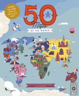
50 Maps of the World
Explore the globe with 50 fact-filled maps!
by Ben Handicott; Kalya Ryan
This title was previously available on NetGalley and is now archived.
Send NetGalley books directly to your Kindle or Kindle app
1
To read on a Kindle or Kindle app, please add kindle@netgalley.com as an approved email address to receive files in your Amazon account. Click here for step-by-step instructions.
2
Also find your Kindle email address within your Amazon account, and enter it here.
Pub Date 7 May 2024 | Archive Date 14 Mar 2024
Quarto Publishing Group – Wide Eyed Editions | Wide Eyed Editions
Talking about this book? Use #50MapsoftheWorld #NetGalley. More hashtag tips!
Description
Geography, history and culture spill from the pages of this luxuriously illustrated treasure trove of travel knowledge for 7-to-10-year-olds. Each two-page spread is dedicated to a different country, providing both quick-fire facts and the chance to delve deeper into what makes every nation unique. Natural wonders, bustling metropolises, storied pasts and cultural icons are all presented in expert detail from experienced explorers Ben Handicott and Kalya Ryan, alongside Sol Linero’s eye-popping artwork.
- Meet our earliest ancestors in Ethiopia, marvel at Machu Picchu in Peru and visit the floating villages of Cambodia in this colorful guide to 50 fascinating countries. It’s a diverse guide that spans from Spain to Singapore, Colombia to Canada, Turkey to Tanzania, and more.
- Each spread includes dozens of spotlighted locations, a timeline of the nation’s history and introductions to the people who have helped shape it.
- With the expertise of Ben Handicott (Hello Atlas, Atlas of Adventures: Wonders of the World) and Kalya Ryan, alongside the stunning illustrations of Sol Linero (The 50 States, 50 Cities of the U.S.A.), experience the diversity of our world like never before.
50 Maps of the World reimagines what maps for kids can be, providing not just a geographical fact-fest but a vivid insight into the history, culture and wildlife that shape our living world. This is the perfect way for aspiring adventurers to find out more about all the exciting destinations around the world. This is a quirky, dynamic book of atlases that makes a perfect companion for vacations and during trip planning.
Also in the series:The 50 States, We Are the United States, 50 Cities of the U.S.A., Only in America, and many exciting, fun-filled activity books.
Available Editions
| EDITION | Other Format |
| ISBN | 9780711291706 |
| PRICE | $14.99 (USD) |
| PAGES | 112 |
Available on NetGalley
Average rating from 71 members
Featured Reviews
Another hit in the “50 maps of” books!
A perfect book for the adventure children of the world! These are auto buys!!
 Christine L, Educator
A cute book of maps from around the world that introduces children to countries and their famous landmarks, customs, and more! I really like the way this was laid out in terms of the maps with illustrations of landmarks and main features. I do think that there was a weird order in the middle where it went to Africa then back to Asia in terms of countries covered (but that seems like maybe it was just a mistake). I think it could have been a cute addition to add continent maps in between to clearly mark sections. But besides that, really cute and a great way to introduce young kids to the wider world!
I received my copy from Netgalley in exchange for an honest review.
This was a beautiful read, full of so many facts across the world, I will definitely use it when I go on holiday next.
This is the perfect combination of beautiful illustrations and detailed information about maps across the world. Adults and children will both learn lots in reading this book.
I love a good map. I’ve lost track of time exploring the world on Google Earth since travel is not always an immediate option. This book is full of maps with fantastic, fun illustrations of famous people, places and important dates and facts about 50 countries. This book would be a perfect book for kids. I think they would enjoy it while they are young and then grow into it to be able to read the information. I think I’ll buy a print copy of it because I love the maps and illustrations.
Thank you for an advanced copy, NetGalley and Quarto Publishing Group – Wide Eyed Editions.
This book is gorgeous, informative, and interesting! The colors and illustrations are engaging. There is a wonderful range of countries representing every corner of the planet. I love the way they teach a little bit of history (Moments to Remember), geography, culture and everything in between with details and interesting facts about the country, the people, and their history. Definitely a must-have for our home library!
Thanks to Netgalley and the publisher for the advanced digital reader's copy (ARC) in exchange for an honest review!
I was given a digital copy of this book as an ARC. That being said I will be purchasing a hardback copy for my family library.
This book has excellent illustrations and information about each country. My 10 year old found it interesting and I did as well. This book is a good reference for any home library.
I've loved maps sińce I was a kid. All those hours looking at them, dreaming. My ever-worring mom must regret bringing home some of them now, when I tell her about a new upcoming adventure.
Either way, I would have loved it as a kid, and I loved it now.
Good job on not only listing the most obvious tourist places!
I love this informative non-fiction book designed for children. After having returned from a trip to South America and Antarctica I happily read this book. This has a format similar to ‘The 50 States’ (May 2024) which I’ve also read. It covers 50 countries giving each two pages. There is an illustrated map that is full of fun information, facts, and mentions of notable people. Key facts are included like: capitol, population, largest cities, money, language spoken etc. There are also historical moments to remember. It obviously doesn’t cover every country in the world but hits the major ones you would expect. This is easily an auto purchase for my school library and I believe it will be very popular.
Katie W, Reviewer
This book is such an educational book about the countries .Geography was not my best subject in school but this book taught me things I did not know.I loved the history that was included with the countries along with key facts .I thought the author did a great job on this book and it showed the author did the research.Thank you net galley for this book.
4.5
So much information, facts, and history on each of these selected 50 countries. I was sad that it didn't have Portugal, but it does have Brazil (although it's not the same, it does teach us a bit about Portugal's history and navigators.) Each double page (or country) chronologically describes the most important events from the start to today. Relevant personalities, monuments and locations, key facts about the population and capital, information on the type of money, and even fauna and flora. I love the artstyle and the design of the pages. It's very educational and useful.
Thank you publisher and netgalley for this e-arc.
I’m a sucker for geography as I studied Tourism years ago. I love facts and history about places and love reading these kinds of books. I did smile at the Netherlands page because some of the information is kind of interesting, and I as a Dutchie would not have thought about including it so I even learned something about my own country. This is an amazing book to teach my children more about the world!
Alicia B, Reviewer
While "50 Maps of the World" is geared toward children, I found it equally fascinating as an adult. The illustrations are amazing and fun to look at! Each country map that is shown includes a brief historical timeline, key people and features of the country, some important facts, and a brief overview of the country. Having completed world history many many moons ago, this is an awesome refresher for adults as they read through it with their kiddos!
This book is perfect for our homeschooling. I love how it's broken down into countires, it makes it super easy to do mini units for our Social Studies. It also gives some science and history facts that the kids love hearing and seeing the pictures
Thank you to the author and NetGalley for this ARC
Packed with history and facts! This book has adorable maps that have key moments in their history, facts and pictures! I loved it. And it was perfect for my kids that are interested in maps and the world!
 Educator 1292066
My children loved this book! We are studying the 50 states this year as part of our homeschool curriculum and using that book as a major part of our studies. So, I was excited to see that this will be released soon, and we can use it next year as we further our geography lessons. I am already getting ideas prepared for how to use it with our curriculum. Lots of information and facts and bright colors! I will definitely be recommending it to others and purchasing it for our homeschool library.
This book is so beautifully illustrated and is a wealth of information about countries all over the world. Broken down I to map form, you get little details about certain locations of historical significance with each country as well as people who impacted the country and a timeline of important dates. So many unique areas of the world are given the spotlight and I loved learning about new to me places as well as more information about countries I have had the privilege of visiting!
just like a previous book from this author, the illustrations are beautiful and the destinstions! i was sooo happy to see lençóis maranhenses in one of the brazilian destinstions since this is where I am from and most tourists just want to visit rio for their beaches when there are many other things to do. i also love how the author included "least popular" yet still interesting countries to talk about, all from every continent in the world. i feel like adults might also be interested in taking a look at this book. i highly recommend!
Megan I, Reviewer
Thank you so much to NetGalley and Quarto Publishing for my copy of 50 Maps of the World by Ben Handicott; Kayla Ryan in exchange for an honest review. It publishes May 7, 2024.
Oh my goodness, this book was so wonderful! As a homeschool mom, the maps in this book are invaluable, and would absolutely enhance any geography lesson! Interesting and fun to view, this book is a real winner!
Educator 995746
This will really appeal to a particular group of children in my class who are fascinated with discovering new facts about the world around. As an adult, I love the combination of historical facts and interesting geographical information. The layout of each page is similar which would also make this appealing for the less confident readers. This is a book which could be dipped in and out of rather than read from cover to cover. You could revisit countries you've been to in real life or simply those on your wish list.
This is going to be a must buy for our school library as I can picture pairs or groups of children enjoying looking at this together.
“50 Maps of the World” is a romp through the world exploring the natural wonders and cultural histories of countries on all parts of the globe. Each double-page spread features a map with bite-sized chunks of text that tell the reader about various aspects of that country. Authors Ben Handicott and Kalya Ryan included five important people and a key facts box from that country.
The design and illustrations of the book are delightful thanks to the talent of illustrator Sol Linero. This book begs to be read as a physical book. I can imagine children (and adults) running their fingers over the pages as they focus on one interesting aspect of the country.
Classroom Considerations: This book is a must-have for elementary classrooms and would be an excellent addition to middle school and high school classrooms.
I received an advance review copy from NetGalley and Quarto Publishing Group for free, and I am leaving this review voluntarily.
This book is a fantastic addition to any map lovers collection. What a fantastic resource for a family with children to have. You could spend a whole hour on each page looking at the map, pictures and place. Each page had me fascinated, and wanting to learn more about the rich culture and heritage of the people who lived there. I especially loved the introduction and how it taught that maps can change and countries can split or unite.
I enjoyed slowly perusing each page and would love to have a copy in our home for the kids (and me!) to read again and again.
5⭐️⭐️⭐️⭐️⭐️
Reviewer 409992
Thank you to NetGalley and the publisher for providing me with this book in exchange for my review! All opinions are my own.
As someone who is an inquisitive person, I found this book interesting. Even though I am 25, I have never had the opportunity to travel out of the United States, unfortunately. However, I have always believed it is important to learn about other lifestyles and cultures besides my own. I also believe it is important to teach children these lessons, and this book accomplishes that without being very overwhelming. With that being said, I don't think this book would be suited for toddlers, but could probably catch a first or second-grader's attention. I would buy this book for a child that may come into my life.
—-
Connect with Me <3
My blog is https://bookreviewsbyjules.blogspot.com/
Goodreads: https://www.goodreads.com/user/show/44083250-julia
Instagram/bookstagram: https://www.instagram.com/bookreviewsbyjules/
Substack: https://bookreviewsbyjules.substack.com/
I love these graphics. This is a perfect book for children to learn and be exposed to all new places and cultures. Quality images and beautifully drawn.
50 Maps of the World is a children's book about a bunch of different countries around the world. It has different places to visit, different historical events, and different facts about these different countries.
This book was a lot of fun! It had a lot of good information that kids will find interesting. I liked the different areas, the different historical facts, and the pictures throughout. It has information for all types of people like history loves and travel lovers. The pictures were all very colorful and cute. The font was also pleasing to look at.
I think a lot of kids will enjoy this book! It has a lot of information and it is really cute to look at! Thanks so much to netgalley and Quarto Publishing Group – Wide Eyed Editions, Wide Eyed Editions for the arc of this book in exchange for an honest review!
I loved this book, and I learned so much that I started taking notes! I will definitely be buying this for some of the kids in my life. The art is stunning, and the information is well organized. I highly recommend this book!
Reviewer 1125037
What a great book for children to learn about the different countries around the world and some facts. I even learned a lot about the countries in this book myself. The pictures are so pretty.
How do you travel without leaving the comfort of your own home? This book is it! It helps the child to see what happens around the world, to spark their interest in foreign cultures and countries. Entertaining, visually appealing, and informative.
What a fun book!! As a kid, I would have devoured this book which has everything I ever wanted! Each page is set up in a similar manner, but have so much interesting information about that country. The table of contents is a map (which is cool) and the 50 countries included have the page numbers on it. The first page is a sample page which explains how each page is set up with the welcome box, spotlight of important facts, moments to remember in a timeline, chart of key details (capital, population, currency, language, motto, national bird, animal, and flower). There is also a glossary and index that are easy to use. As you turn each page, you travel the world and are immersed in the their history and the culture. Kids can read and explore this book on their own or can read with family to dream of travel to far away lands.
I would recommend this for any teacher, parent, or adult with elementary age children. It could open up a whole new world to explore.
Thank you Net Galley for a complimentary copy. All opinions expressed are my own.
Kina T, Reviewer
My little one loves this book. We started studying each country and city. Each city has interesting facts about it, as well as notable people from the cities. My 6 year old loves to learn new things, and is eager to keep going over this book.
Thank you to Netgalley and the publisher for this book in exchange for my honest review.
Reviewer 1265715
We love an atlas. We love a thoroughly engaging atlas even more! This great new non-fiction release from Wide Eyed Editions is colourful, engaging and absolutely brimming with fabulous facts.
With a wealth of knowledge on every page, sections for each country include:
Welcome Box – a general introduction to the country pictured.
A timeline – summarising the history of the chosen nation
People of Note – five inspiring members of the population. eg India: Mahatma Ghandi led India to independence from British rule
Country Icons – eg Kenya: In the Great Rift Valley in Kenya, you can see the Earth’s crust moving!
Key facts – eg Greece: The National Flower of Greece is the Bears Breeches
Moments to Remember – eg UK: In 1928 women in the UK gained the same voting rights as men.
and a
Spotlights eg – The Queen of Sheba’s bath is in Ethiopia
- Indonesia is home to the world’s largest flower, Rafflesia arnoldii
- Barracuda Lake in the Philippines is warm in parts and cold in other
All of these gems and hundreds more can be found in this compendium which re imagines atlases for children and proves that the world of cartography is fun, engaging and exciting. Its rich and luxurious illustrations support the text perfectly and combined, they make the perfect introduction to the countries and the diverse tapestry of life within them for children age 7-10.
Thank you to Net Galley and Wide Eyed Editions for sending this eBook for review consideration. All opinions are our own.
Reviewer 1093198
Very cute illustrations and liked the facts and history of the included countries. Wish more countries were included! Will definitely get this for my kids to enjoy!
Readers who liked this book also liked:
Haddy Njie
Children's Fiction, OwnVoices, Parenting, Families, Relationships

Agatha Christie
General Fiction (Adult), Historical Fiction, Mystery & Thrillers
Crystal Radke
Children's Nonfiction, Parenting, Families, Relationships
We Are Bookish
Biographies & Memoirs, Health, Mind & Body, Nonfiction (Adult)
We Are Bookish
LGBTQIA, Romance, Sci Fi & Fantasy
Views expressed in promotions/advertisements do not necessarily reflect those of NetGalley or its affiliates.
© 2026 NetGalley LLC
• All Rights Reserved


Views expressed in promotions/advertisements do not necessarily reflect those of NetGalley or its affiliates.